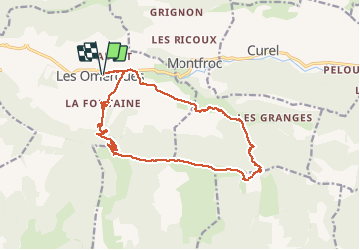
LES OMERGUES pas de Redortiers . Crêtes de la Faye col de la Roche. Ville o vieille

RobinMicheline
User GUIDE

Length
18 km

Max alt
1428 m

Uphill gradient
740 m
Km-Effort
28 km

Min alt
796 m

Downhill gradient
739 m
Boucle
Yes
Creation date :
2019-07-13 04:06:19.226
Updated on :
2020-01-31 19:03:13.967
6h45
Difficulty : Very difficult

FREE GPS app for hiking
 SityTrail
IGN / Geographical institutes
SityTrail Plus
The world is yours!
About
Trail Walking of 18 km to be discovered at Provence-Alpes-Côte d'Azur, Alpes-de-Haute-Provence, Les Omergues. This trail is proposed by RobinMicheline.
Description
18 kms 5 h 30 marche un peu long .Belle vue en haut
Positioning
Country:
France
Region :
Provence-Alpes-Côte d'Azur
Department/Province :
Alpes-de-Haute-Provence
Municipality :
Les Omergues
Location:
Unknown
Start:(Dec)
Start:(UTM)
708467 ; 4894273 (31T) N.
Comments